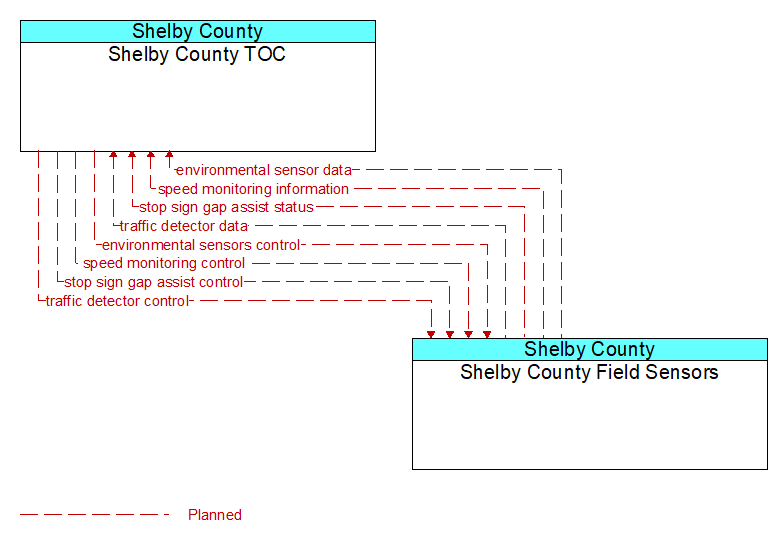
Interface: Shelby County TOC - Shelby County Field Sensors

Architecture Flow Definitions
environmental sensor data (Planned) Applicable ITS Standards
Current road conditions (e.g., surface temperature, subsurface temperature, moisture, icing, treatment status) and surface weather conditions (e.g., air temperature, wind speed, precipitation, visibility) as measured and reported by fixed and/or mobile environmental sensors. Operational status of the sensors is also included.
environmental sensors control (Planned) Applicable ITS Standards
Data used to configure and control environmental sensors.
speed monitoring control (Planned) Applicable ITS Standards
Information used to configure and control automated speed monitoring, speed warning, and speed enforcement systems.
speed monitoring information (Planned) Applicable ITS Standards
System status including current operational state and logged information including measured speeds, warning messages displayed, and violation records.
stop sign gap assist control (Planned) Applicable ITS Standards
Configuration and control of detectors that monitor traffic on the major road and signs that provide stop sign gap assist alerts and warnings to vehicles on the minor road.
stop sign gap assist status (Planned) Applicable ITS Standards
The current operational state and status of the field controller, sensors, and signs that support the stop sign gap assist application.
traffic detector control (Planned) Applicable ITS Standards
Information used to configure and control traffic detector systems such as inductive loop detectors and machine vision sensors.
traffic detector data (Planned) Applicable ITS Standards
Raw and/or processed traffic detector data which allows derivation of traffic flow variables (e.g., speed, volume, and density measures) and associated information (e.g., congestion, potential incidents). This flow includes the traffic data and the operational status of the traffic sensor system.