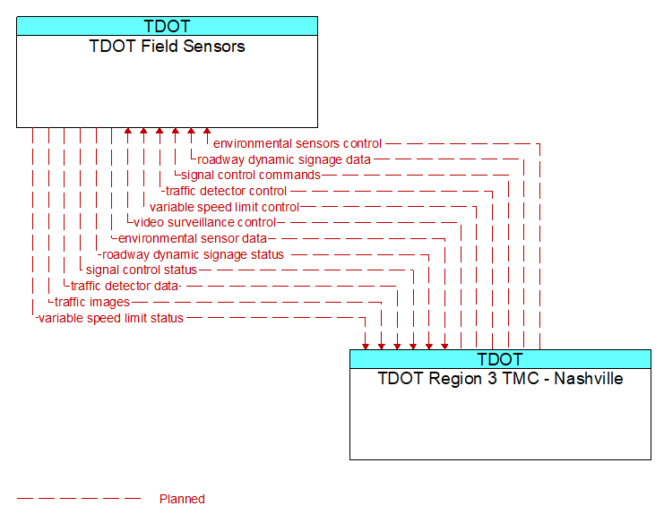
Interface: TDOT Field Sensors - TDOT Region 3 TMC - Nashville
Information Flow Definitions
environmental sensor data (Planned)
Current road conditions (e.g., surface temperature, subsurface temperature, moisture, icing, treatment status) and surface weather conditions (e.g., air temperature, wind speed, precipitation, visibility) as measured and reported by fixed and/or mobile environmental sensors. Operational status of the sensors is also included.
environmental sensors control (Planned)
Data used to configure and control environmental sensors.
roadway dynamic signage data (Planned)
Information used to initialize, configure, and control dynamic message signs. This flow can provide message content and delivery attributes, local message store maintenance requests, control mode commands, status queries, and all other commands and associated parameters that support remote management of these systems.
roadway dynamic signage status (Planned)
Current operating status of dynamic message signs, highway advisory radios, or other configurable field equipment that provides dynamic information to the driver.
signal control commands (Planned)
Control of traffic signal controllers or field masters including clock synchronization.
signal control status (Planned)
Operational and status data of traffic signal control equipment including operating condition and current indications.
traffic detector control (Planned)
Information used to configure and control traffic detector systems such as inductive loop detectors and machine vision sensors.
traffic detector data (Planned)
Raw and/or processed traffic detector data which allows derivation of traffic flow variables (e.g., speed, volume, and density measures) and associated information (e.g., congestion, potential incidents). This flow includes the traffic data and the operational status of the traffic sensor system.
traffic images (Planned)
High fidelity, real–time traffic images suitable for surveillance monitoring by the operator or for use in machine vision applications. This flow includes the images and meta data that describes the images.
variable speed limit control (Planned)
Information used to configure and control variable speed limit systems including the equipment used to provide current speed limits and other information to drivers and the equipment used to monitor traffic and environmental conditions along the roadway.
variable speed limit status (Planned)
Current operating status of the variable speed limit systems including the state of the equipment.
video surveillance control (Planned)
Information used to configure and control video surveillance systems.